1. War and peace in the western Mediterranean
In the 7th century, the western Mediterranean was shared by three powers. The Byzantine empire held north Africa, the Balearic islands, Corsica, Sardinia and Sicily, and certain regions in the Italian coast. The remaining part of Italy was dominated by the Lombards who tried to conquer the entire island. The Visigothic kingdom controlled the Iberian peninsula. Between 665 and 709, the Caliphate progressively took hold of north Africa. Although the conquest of the Iberian peninsula and Italy emerged as the logical conclusion of this advance, the two cases were quite different.
Spain: conquest and reconquest
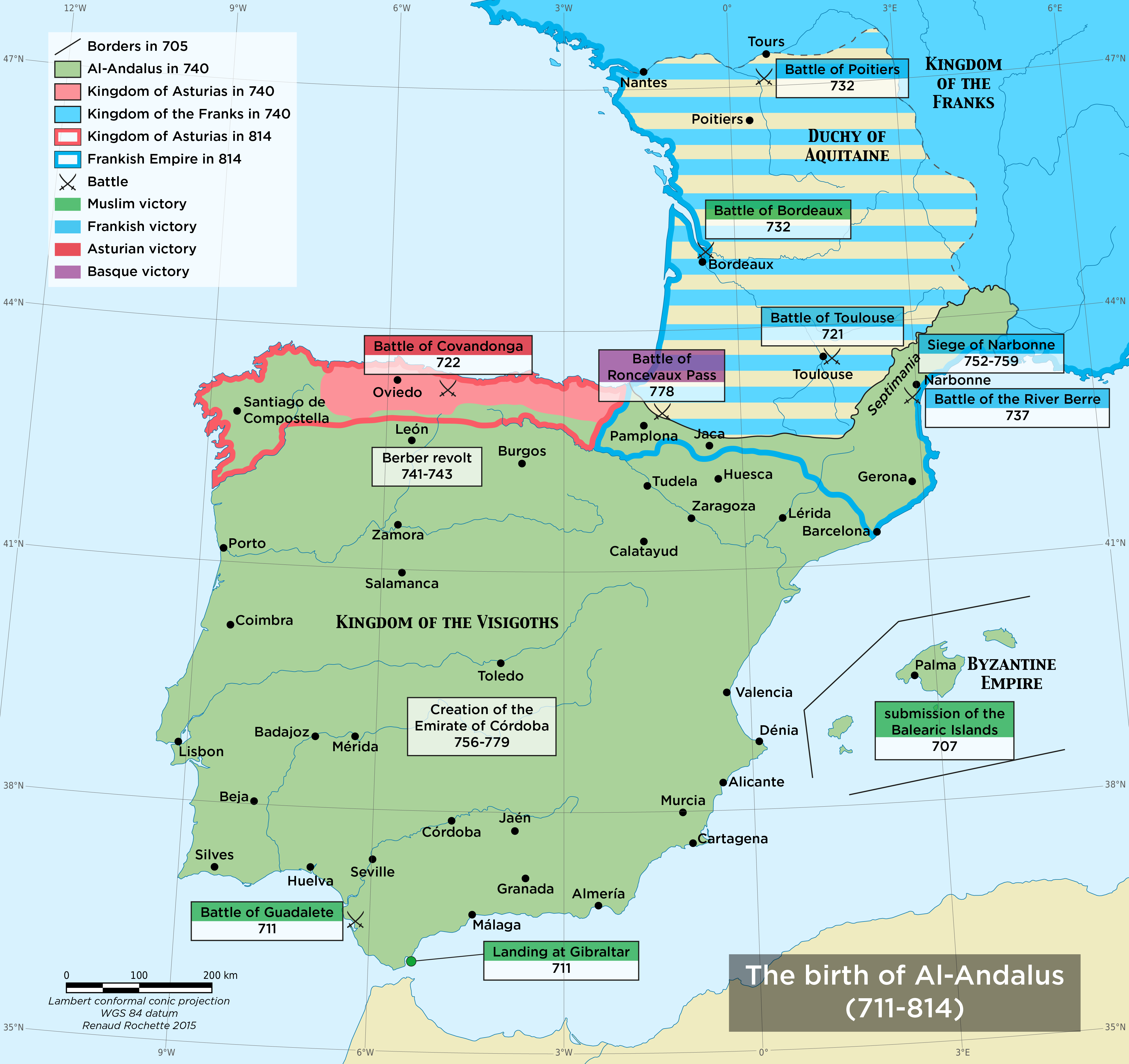
In 711, Tariq ibn-Ziyad landed in Gibraltar with a small army. The kingdom of the Visigoths was weakened by strong internal dissent. King Roderic (r. 710-711) was defeated and killed at the battle of Guadalete. After receiving reinforcements from North Africa, Tariq completed the conquest of the Iberian peninsula in seven years.
In 719, Muslims entered Gaul and seized Septimania, which was a Visigothic province. From there they launched a series of raids in the Aquitaine region, but were defeated at the battle of Toulouse (721).
In 732, a new invasion inflicted serious defeat on the troops of the Duke of Aquitaine, who called for the help of Charles Martel, mayor of the palace of the Franks. He took advantage of the situation to reaffirm the authority of the Franks over the Aquitaine and made a decisive victory at the battle of Poitiers (732), which was the furthest point of Muslim expansion in the West.
Charles Martel then turned towards Septimania: although the military campaign there failed, it brought an end to the Muslim invasion of Gaul. Septimania was conquered by Pepin the Short (r. 751-768) between 752 and 759. In 778, Charlemagne led an expedition beyond the Pyrenees. Its results were modest but it led to the creation of the Spanish March where preparations for the Reconquista were made.
The conquest of the Iberian peninsula remained incomplete. The invasion of Gaul allowed Pelayo/ Pelagius (r. 718-737), a noble Visigoth, to regroup those who opposed the Muslim presence in the mountain areas of the northern Iberian peninsula and establish the Kingdom of Asturias. In 722, he won the battle of Covadonga against the Muslim troops that had come to put down the revolt. Although it was only a skirmish, this event had great repercussions: it guaranteed the existence of the Christian kingdom and marked symbolically the beginning of the Reconquista.
The Reconquista (reconquest) was not linear, nor inevitable; it was made of incursions, skirmishes and progressive encroachments and went through phases of acceleration and sudden stops.
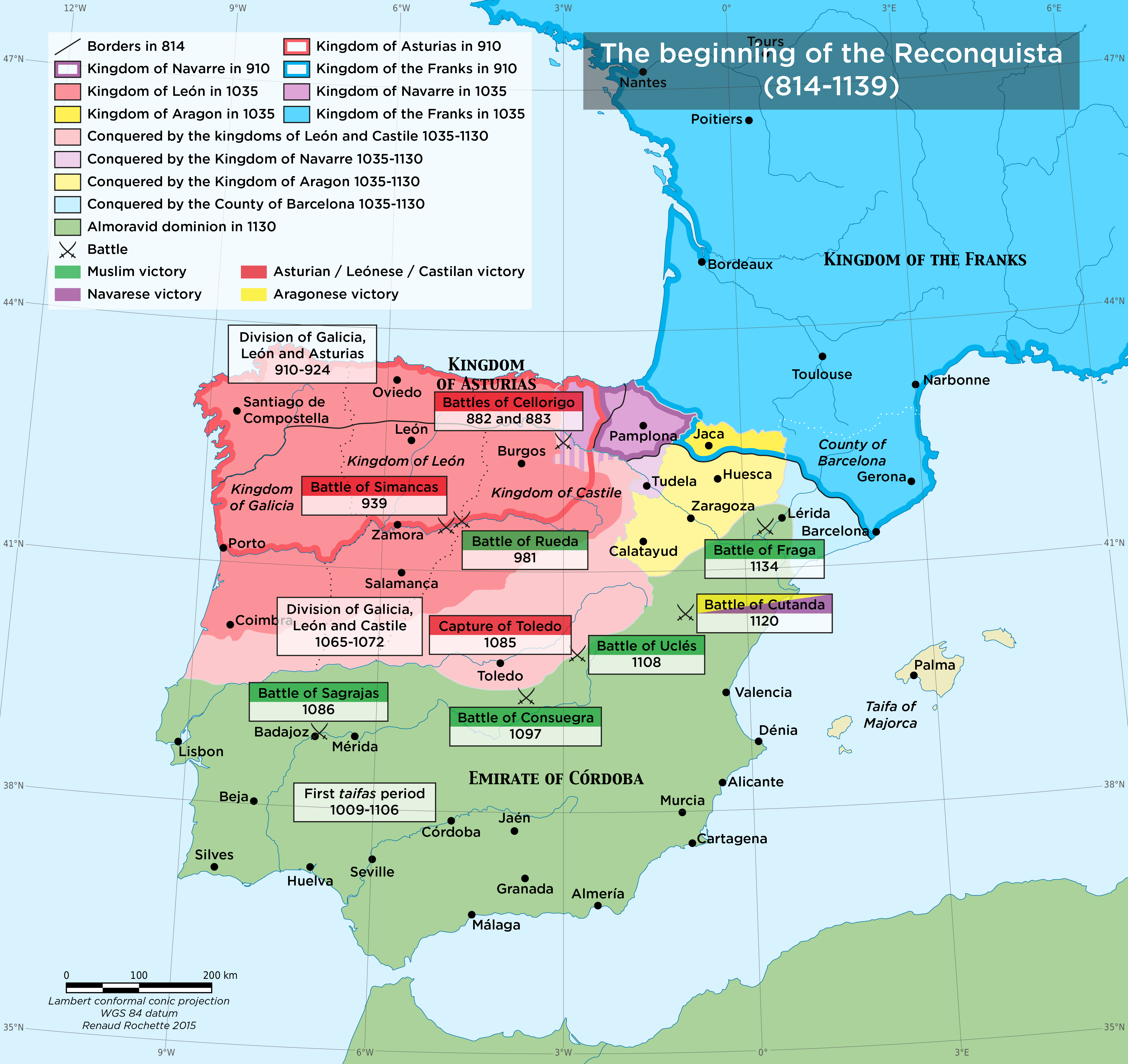
The first major expansion of the Kingdom of Asturias took place around 740. The tensions between the Arabs and the Berbers led to a revolt by the latter in 740 in the Maghreb, and in 741 in Al-Andalus. The departure of garrisons from the north towards the south, where most important combats took place, allowed the Kingdom of Asturias to expand and create a buffer zone around the Douro valley. Despite the repression of the revolt, the situation slipped from the control of the Caliphate, whose authority over the Maghreb and Al-Andalus became very speculative.
In 750, the dynasty of the Umayyad Caliphate was overturned and replaced by the Abbasids. Abd al-Rahman (r. 756-788), the only one to have survived the massacre of his family, took refuge in Al-Andalus, where he established an emirate independent from the Caliphate by rallying and forcing local governors to surrender (756-779). During this period of unrest, the Franks made advances in the northeast. In 929, Abd al-Rahman III (r. 912-961) was proclaimed Caliph, thus becoming a successor of the Prophet and a true competitor to the Abasid Caliphate.
The Emirate/Caliphate of Cordoba, and more particularly the reign of Abd al-Rahman III, was the peak of Al-Andalus. In the North, the Christian kingdoms continued their progressive advances.
This expansion came suddenly to a halt with the military campaigns of vizier Muhammad ibn Amir, also known as al-Mansur (the victorious), called Almanzor in Spanish. Between 977 and 1006, he led various military campaigns that helped him gain access to the heart of León and Castile. He thus stabilized the borders.
The Caliphate of Cordoba collapsed when a conflict over succession broke out in 1009. Certain regions took advantage of the chaos to organize themselves into small independent kingdoms, called taifas (from the Arabic ṭā’ifa, part). The Caliphate was finally abolished in 1031. The Christian kingdoms, despite internal dissent, took advantage of the situation to continue their expansion at the expense of Al-Andalus.
In 1085, the capture of Toledo by Castile came as a shock. In addition to its prestige as the ancient capital of the Visigoths, the city was one of the richest in Spain. For the Muslim elites, what was most shocking was that the capture of the city seemed as retribution for the assistance by Castile in the conflict between the taifa of Toledo and Valencia, and that of Badajoz.
The Muslim elites stopped lending their support to the Muslim princes of Al-Andalus and decided to call on the Almoravides, a Berber dynasty from Morocco that took control of North Africa. The
Almoravides came to Spain after a crushing victory over the kingdoms of Castile and Aragon in Sagrajas (1086) before defeating the taifas one by one.
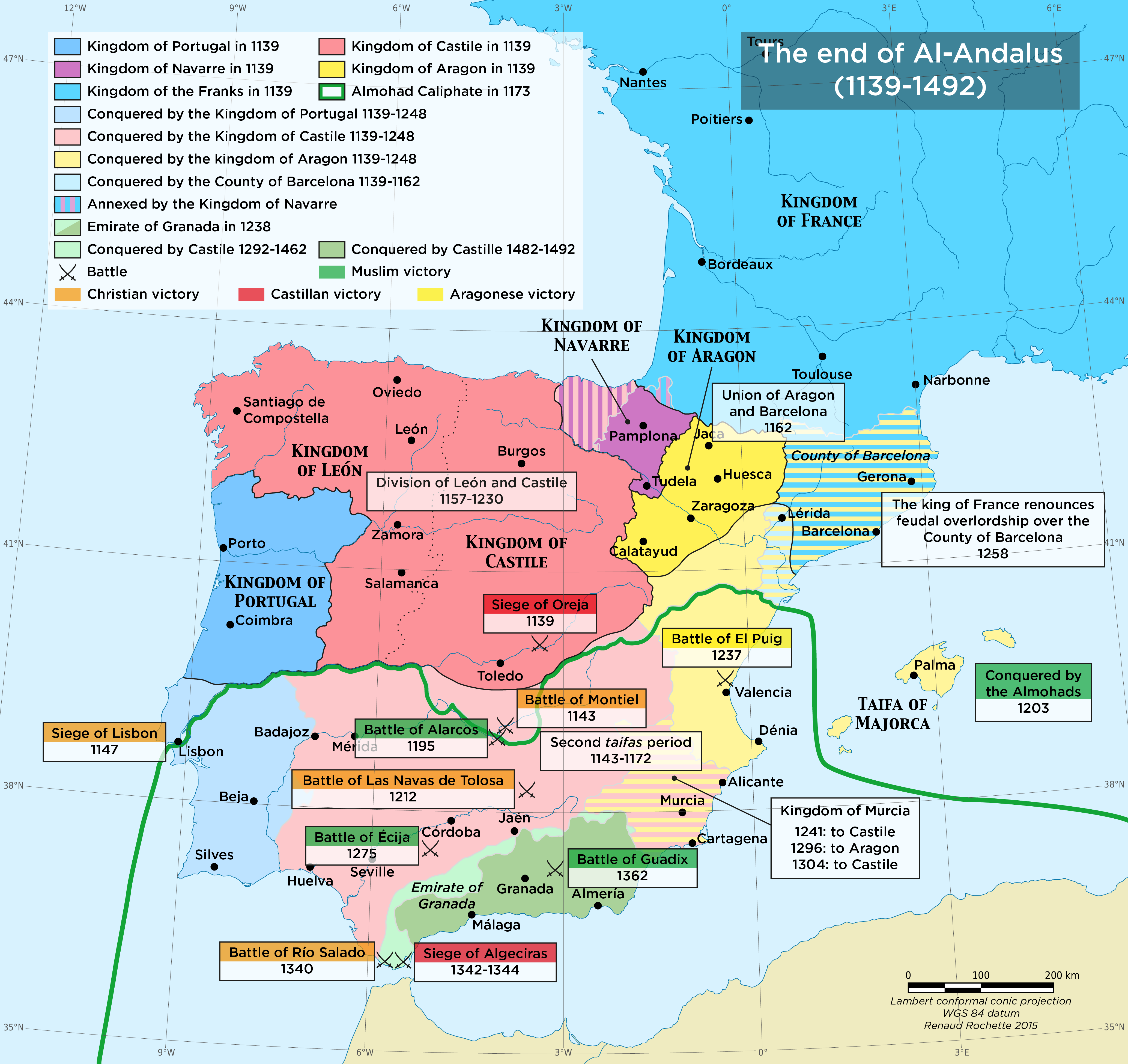
During the Almoravide period there was a relative stabilization of the situation, but also a hardening on both sides of the border. The Almoravides were primarily a religious movement seeking a return to an intransigent version of Islam. In Christian Spain, the growth of the idea of a crusade in 1095 resulted in the rush of knights who were eager to fight the Muslims, thus leading to the creation of the powerful military religious orders that were unique to the Iberian peninsula, such as the Order of Aviz (1146), the order of Calatrava (1157) and the order of Santiago (1158).
The Second Crusade (1145-1149) was a time of a new Christian expansion. Even if its main objective was to offer support to the Latin states in the East, it was conceived as an offensive against the enemies of Christianity. The campaign by King Alfonso VII of León and Castile (r. 1126-1157) was part of the Crusade. The crusaders lent their support to King Alfonso I of Portugal (1139-1185) during the siege of Lisbon (1147).
The Almoravides started losing control of the situation. In Africa, they lost ground after facing another rigorist movement, the Almohades, who revolted against the Almoravides in 1121. In 1147, the Almohades captured Marrakesh, the Almoravid capital, and proclaimed a new Caliphate. From 1144, new taifas were established in Al-Andalus, but this second period was short-lived. In 1147, after capturing Lisbon, the Muslim elites called the Almohades for help: in 1153, they defeated all the taifas with the exception of the taifa of Murcia and Valencia, which resisted until 1172.
The Almohades managed to contain the expansion of the Christian kingdoms, thanks to the victory of Alarcos (1195). However, the situation did not remain stable for long. In 1212, a coalition of the Kingdoms of Aragon, Castile, Navarra and Portugal defeated the Almohade army at the battle of Las Navas de Tolosa. The succession crisis that began in 1224 within the caliphate started a new period of taifas, but this time they were conquered by the Christian kingdoms between 1228 and 1248. Only the Emirate of Granada managed to survive until 1492.
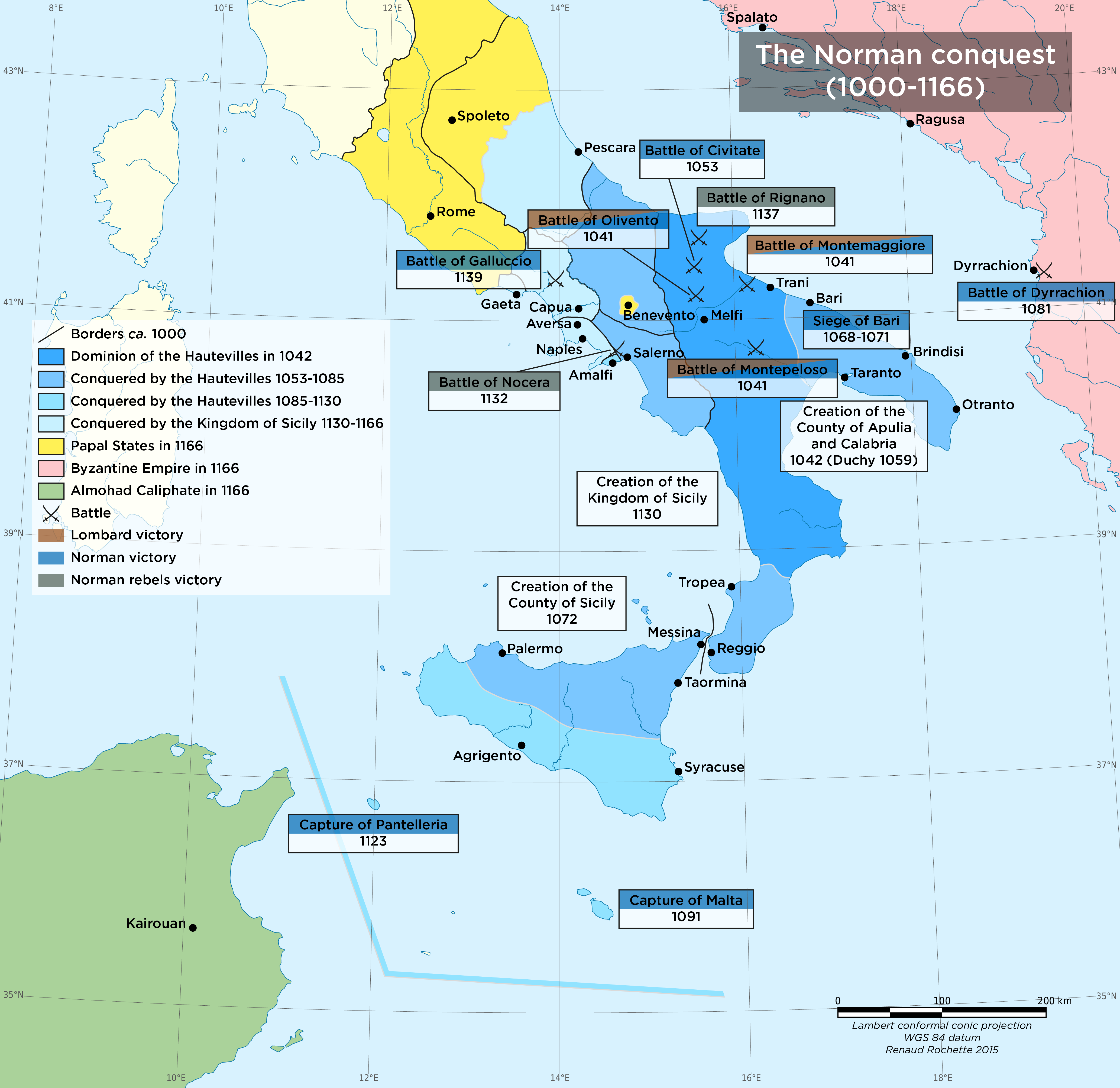
Southern Italy: an area of contact and conflict
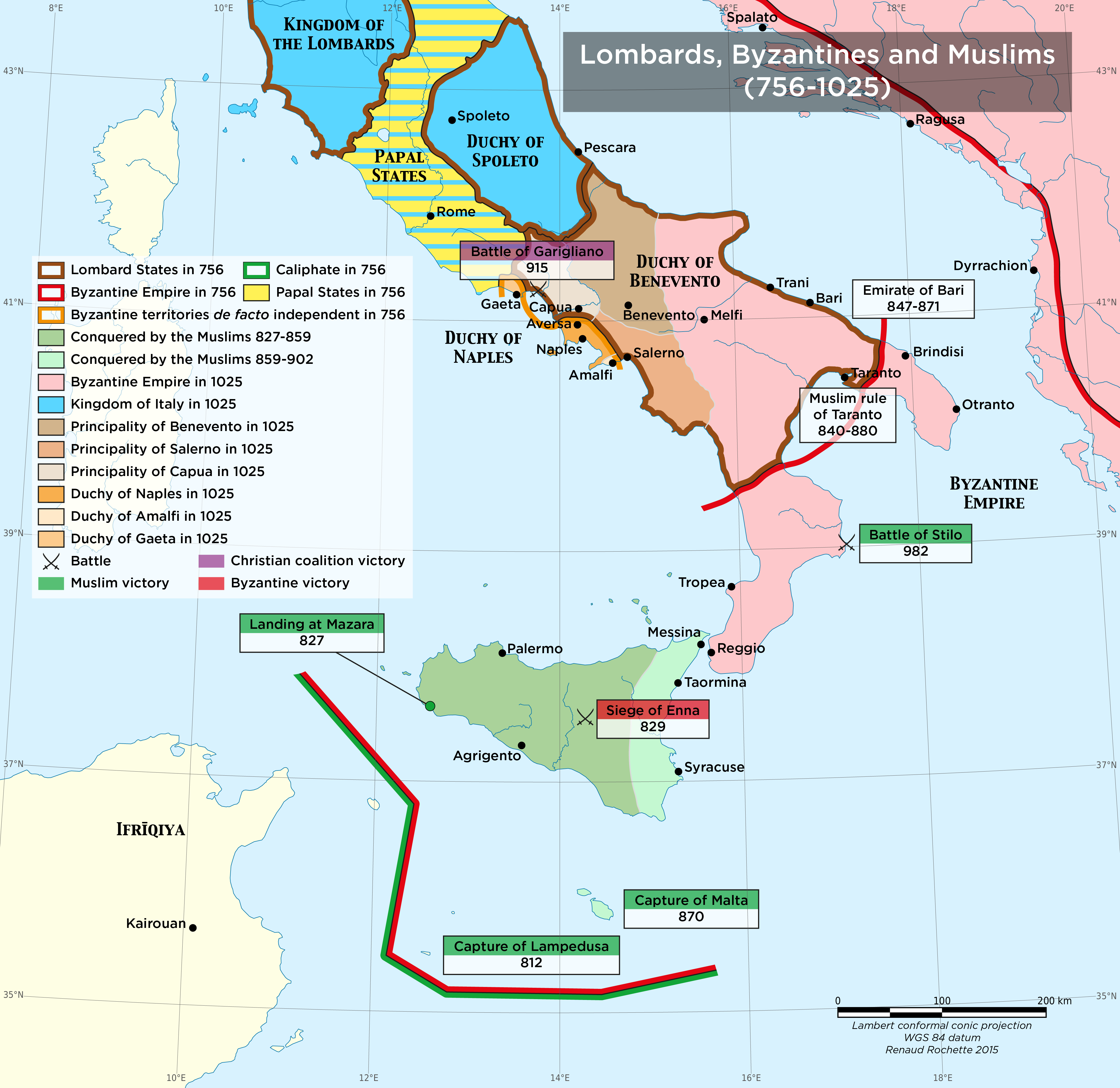
Since Antiquity, southern Italy has been an area of contact between Latins and Greeks. The Roman conquest did not destroy the Greek population. Italy was conquered once again by the Byzantine Empire in 553 but, after 558, the Lombards invaded the peninsula. Byzantium held on to a few coastal regions while the Lombards tried to reunite the peninsula.
The arrival of the Francs tipped the balance. In 754 and 756, Pepin the Short (r. 751-768) led two expeditions against the Lombards thus creating the papal states. In 774, the conquest of the kingdom of the Lombards by Charlemagne spared only the principality of Benevento. As the Byzantine Empire affirmed its Greek character and after the Byzantine church was separated from the Roman church, Italy became an area of confrontation between the Latin and Byzantine Christianity.
Despite this turbulent history and with the exception of coastal raids, southern Italy was not affected by the Muslims who settled in North Africa. Muslim attempts to settle in Italy in 740 and 812 failed.
In 827, taking advantage of the call for help by a rebellious Byzantine dignitary, the emir of Ifrīqīya began the conquest of Sicily. Despite the difficulties in the beginning, Muslim troops seized the western part of the island. In 831, they captured Palermo, which became the capital of Muslim Sicily. Muslim expansion in the remaining part of the island was very slow: Taormina, the last city under the Byzantine empire, was captured in 902. Sicily became a base from which Muslim ships raided the Italian coastline, but their attempts to settle in the Italian peninsula failed.
At the same time, the principality of Benevento was weakened and fragmented. The Byzantine empire took advantage of the situation to gain ground in the peninsula.
At the end of the 10th century, southern Italy was in a state of disarray with Byzantine provinces, some of which were de facto independent (Naples and Amalfi), an emirate in Sicily, the principalities of Lombardy and the papal states along with incursions by the kings of Italy who held the northern part of the peninsula. Alliances were in constant flux and each tried to take advantage of the situation to consolidate and expand their holdings.
An outside player turned the game upside down. In the beginning of the 11th century, the Normans came to southern Italy to be recruited and work as mercenaries in this almost permanent war. In 1030, they settled in the area when Ranulf Drengot was appointed first Count of Aversa by the Duke of Naples. In 1042, after the successful revolt of the Lombards against Byzantium, William of Hauteville (also known as William Iron Arm) took control of the County of Apulia. Subsequently, the Normans stopped working as mercenaries and started conquering southern Italy on their own.
The Byzantine empire progressively lost its Italian lands: Bari was the last Byzantine city to be conquered by the Normans in 1071. The Lombard principalities also fell one by one.
After 1061, Robert Guiscard, one of younger brothers of William of Hauteville who had become the Duke of Apulia in 1057, started conquering Sicily. In 1072, he captured Palermo and made Roger Bosso, the youngest of the Hauteville siblings, Count of Sicily. The conquest of Sicily temporarily stopped because certain favourable circumstances made it possible for Robert Guiscard to defeat the principalities of Amalfi, Salerno and Benevento (1073-1080). From 1081 to 1085, he crossed the Strait of Otranto and attacked the Byzantine empire in the Balkans. The intervention of the German emperor and of Venice forced Robert Guiscard to go back to Italy. The Byzantines took advantage of his absence to regain lost ground.
In the absence of Robert Guiscard, Roger Bosso (King Roger I of Sicily) undertook the conquest of the island after 1077. By 1091, the island was completely under Norman control.
Upon the death of Robert Guiscard (1085), southern Italy remained fragmented but the situation improved. The Normans controlled three principalities (the Duchy of Apulia and the County of Sicily held by the Hauteville dynasty, the Principality of Capua held by the Drengot dynasty), while the Duchy of Naples and the city of Amalfi remained independent. Amalfi surrendered in 1089 but rebelled regularly until 1131. In 1127, with the death of King William II of Apulia without a successor, King Roger II of Sicily (r. 1105-1154) united the two lands held by the Hauteville dynasty. He was crowned King of Sicily in 1130. Despite the defeats in Nocera (1132) and Rignano (1137), King Roger II was in a position to make his adversaries surrender. The Duchy of Naples was defeated in 1139 and the principality of Capua in 1156. In 1139, after having been captured and imprisoned at the battle of Galluccio, the Pope proclaimed Roger II as King.
The Hauteville dynasty reigned in la Sicily until 1194. It put into place a unique state mechanism aiming to use the best features put in place by its predecessors in Sicily, where an Arabic-Byzantine-Norman culture flourished [see module on Spain and Sicily, section 3].